California High-Speed Rail Authority
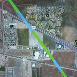
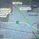
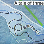
Above, a section of a California High-Speed Rail Authority map illustrates the history of transportation over the Tehachapi pass throughout three centuries. The location is seven miles west of the city of Tehachapi. The black winding line with hatch marks is the railroad track that the Southern Pacific Railroad completed in 1876, now owned by Union Pacific and leased by BNSF for freight trains. The circle in the middle is the famous Tehachapi Loop, an engineering feat built to compensate for the steep grade. The wide white line is State Route 58, the freeway completed in 1964 that is a main east-west motor vehicle arterial across California. The green and blue line is the proposed high-speed electric rail line that will connect northern and southern California. The green color indicates a section of the track to be built on grade, or surface; blue indicates an elevated section. Sections elsewhere are underground. The blue meandering line is Tehachapi Creek; the smaller white line is Woodford-Tehachapi Road. Broome Road gives access to the Broome Ranch. Passenger rail service over Tehachapi summit halted in 1971, and the Tehachapi high-speed rail route will close the transportation gap between the Central Valley and Southern California. The approximately 78-mile ride between Bakersfield and Palmdale stations will take 20 to 25 minutes. Once in Palmdale, passengers can continue to Los Angeles or proceed to Las Vegas via Victorville on a planned private line.