
By Sarah Rose
contributing writer
Golden Hills Nature Preserve
Hike Up

Sarah Rose
Time and the trees attempting to hide signs of humans.
Over the past month or so, there has been a plethora of people on foot in the downtown area of Tehachapi. These folks with tanned, strong legs, often wearing backpacks that seem to weigh more than they do, are Pacific Crest Trail (PCT) hikers. They are in town to rest, refuel and recharge before getting back on the trail. In hiker lingo these are called "zero" days: a day where they are not gaining any mileage to the end the trail which is still over 2,000 miles away at the Canadian border.
Not every hiker starts at the southern terminus at the border with Mexico and not all will continue to Canada. Their routes and destinations are as unique as they are. Those who hike the PCT, often alone, are a different breed of hiker on a level that many of us will never experience, but that doesn't mean we can't get the same benefits and enjoyment out of hiking albeit at a less intense level.
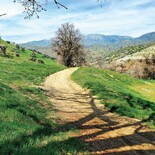
A perfect beginner's trail exists right here in Tehachapi at the Golden Hills Nature Preserve located at 22630 Woodford-Tehachapi Rd. Park your vehicle in the cleared lot and then set off in an easterly direction along the level path, skirting the edge of Tom Sawyer Lake. Follow the path past the lake where it will then turn in a northerly direction, heading you toward the train tacks and 58 freeway in the distance.
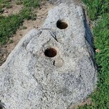
If you take the hike in early to mid-spring like I did, you will find yourself walking along tall green grass and sprawling beds of vinca vines in a valley sheltered by hills to your left and right. Even though there are homes on the hills above and the freeway visible ahead, it's easy to forget about modern life and imagine the first occupants of the area, the Kawaiisu. There are still signs of their life in the valley in the form of a grinding stone just off the path.
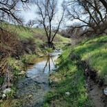
The path splits as it nears the freeway giving explorers the choice to go right and head back toward town or left, following the freeway and train tracks in the direction of Keene along Tehachapi Creek. If it's early enough in the year or if we've had a particularly wet winter, the creek will be running. There are several shady areas to take off your shoes and dip your toes into the gentle stream.

Sarah Rose
The trail heading northwest mirroring the tracks.
There is no real "endpoint" to this trail that I have discovered yet. On my most recent hike I walked 2.5 miles before deciding it was a good point to turn around. I use a free app called Map My Walk created by UnderArmor. I like the app as it uses a GPS system rather than cell signal so it continues to function even when I'm out of cell range. It has saved me a few times on other hikes when I was somewhat lost. I just followed the path that I took in but in the other direction, using the app to guide me.
So put on your sturdy shoes, hat and sunscreen, pack a light bag with plenty of water and snacks and get hiking. It may not be 2,600 miles on the PCT but it still counts as a hike and has many of the same benefits.
*Golden Hills CSD would like to remind everyone that the trails are off limits to all motorized vehicles including dirt bikes and ATVs.
Sarah Rose, local business owner, nature lover and writer would love your feedback and hiking ideas at info@healthyhippietradingco.com.