
Pacific Crest Trail hikers in Tehachapi
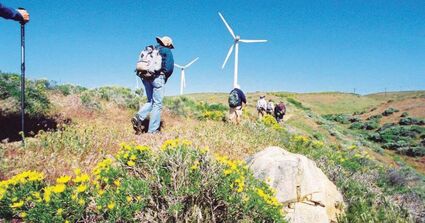
Photo provided
PCT hikers May 2017.
The Pacific Crest Trail (PCT) covers 2,663 miles of rugged terrain following the ranges of California, Oregon and Washington. Most hikers start at the Mexican border and, if they finish, complete the hike at the Canadian border.
They gain significant altitude as they cross the towering Sierra Nevada and Cascade ranges. The National Park Service designated the route as a National Scenic Trail in 1968. It was completed and dedicated in 1993. The trail goes through western Antelope Valley and over the eastern end of the Tehachapi range.
For a PCT hiker, arrival at Tehachapi is a milestone. Each hiker is different, some experienced backpackers and some neophytes, many from outside the United States. Our citizens who offer rides and other assistance really enjoy getting to know these interesting visitors.

Hikers move north in the spring and cross Tehachapi Willow Springs Road at Cameron Canyon where they can call for rides into Tehachapi. That's where the Tehachapi PCT Angels usually help. In past years this group of about forty volunteers, formed in 1996, had been available to give rides and assistance in many ways. The hikers – having completed the arduous first section of the trail – pause in Tehachapi to recharge and pick up supplies mailed to them at our post office, wash their clothes, have good meals at our restaurants,and perhaps catch the latest film at the Hitching Post. Also in past years, the City of Tehachapi Municipal Airport provided hikers a place to sleep for up to three days in Aviator Park for $5 a day. The COVID-19 pandemic has put a halt to that activity until at least 2023.

The Tehachapi PCT Trail Angel committee is also unavailable in 2022, although individuals have posted on Facebook if and when they are available to assist hikers. See Facebook group "Tehachapi Pass (Tehachapi and Mojave) PCT Trail Angels."

From late March through June, hikers can be seen all over downtown Tehachapi, easily identified by their backpacks, hiking boots, tans and beards. A few straggle through until winter.
After spending time in town, most hikers find their way back to Cameron Canyon and walk the trail as it continues through the wind turbines north toward Highway 58. Both the Cameron Canyon/Tehachapi Willow Springs Road and Cameron Canyon/Hwy 58 trailheads are about 9 miles from Downtown Tehachapi. After crossing Hwy 58 the refreshed hikers climb into the southern Sierra Nevada where there is no reliable water for almost 20 miles.
Historically, nearly 1,000 hikers passed through Tehachapi annually. Many hikers complete the PCT in sections over a few years, hiking 10-20 miles a day. The PCT has become more popular because of the best seller "Wild" written by hiker Cheryl Strayed. She describes her experiences and impressions on and off the trail. This interesting book was also made into a film starring Reese Witherspoon.
In the future, 38 miles of the trail will be realigned through the breathtaking vistas of the Tejon Ranch with the Tehachapi rest stop remaining as it is now.
Hikers come from all over the world. They are interesting to talk to and appreciative of rides and assistance while they are here. Join in and show them our warm hospitality. They rave about our special town as they hike north.