
By Sam K White
PCT Section E: Part 1, Desert
Adventure On The Trail
Sam White
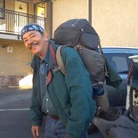
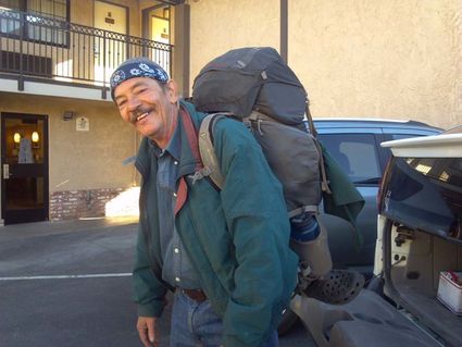
Sam heading out on another adventure.
"The Trail" is the Pacific Crest Scenic Trail (PCT). It begins at the Mexican border, travels north through some of the most beautiful, at times the most dreadful, most picturesque and sometimes untidy scenes of the western edge of North America. Mountains, lakes, rivers, streams, wildlife, deserts and too many small things to mention are along the trail that wanders up-and-down and left-and-right, then ends up some 2,650 miles later.
I chose to be a "section hiker." Little bites here and there of the trail. There are five things necessary to have in place before venturing out on sections or doing all the miles in a calendar year.
One: Support.
Two: Capabilities, mental and physical.
Three: Monetary.
Four: Equipment.
Five (and perhaps this should be first):
The Trail.
I have all five.
To take the first step on the adventure, I did a 16 mile portion of Section E last week. Section E of Pacific Crest Trail is about 110 miles in distance on the trail from Agua Dulce, CA to Highway 58 at Cameron Road in California. The chunk I chose was the trail from Hiker Town, trail mile 518, where the PCT crosses Highway 138. Hiker Town is not a "town" but a private residence that contains some wonderful Trail Angels. It is a place where hikers can stop, converse with the hosts, other travelers and to rest a bit.
From here the PCT heads north. At the trailhead my support Claudia whispered me well on my journey. A soft breeze blew with the temperature in the mid 50s, my 20 pound pack felt heavy. I could see the valley floor stretching north toward the Tehachapi Mountains; looked like a long walk.
Along the trail I check in with Claudia frequently to let her know my progress and that I am still alive. I I have my cell phone, used in prearranged times or emergencies, which I think will not occur, but who knows? Currently I'm at a little dip in the trail. The trail to this point, mile 522, gives a view of what is beyond. It appeared in view and on map very flat, and follows the aqueduct for miles. The black-tarred, eight-foot-diameter pipe is mostly buried, but at this lowest point in the Antelope Valley, 2865-feet, it crosses the sandy wash of a seasonal stream.
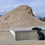
This was a nice resting spot, as there is shade and even struggling Cottonwood trees. An overused couch is there in the sun. If one desires a couch, an old broken fridge or something similar, it might be here. The visual is not nice, mostly an ad-hoc garbage dump, with the collection of all things not needed. The wash has steep banks, so Bubba said, "Dump it over and it'll be outta sight, outta mind".
There is also the beauty of Mother Earth along this trail. I had just passed through a delightful huge grove of Joshua Trees. It is a virtual forest, the trees mostly ten foot high and smaller, with a few here and there some 15 to 20 feet. They are packed, the long sword-like leaves brushing the tips of their neighbors, reminding me what a can of sardines would look like with the little fish standing instead of laying, tight together.
I continue along the trail/road alongside the aqueduct. About every half mile there is a block of concrete. It has a lid, 3" thick, impossible to lift without heavy equipment. I can hear the water flow and wonder what would it be like if I was here out of water, it was 100 degrees and I could hear the water, but the water was untouchable. I shake the thought off and take a seat.
The blocks are 30' long, 12' wide and 3' high, which make a perfect bench to sit have a snack and gaze at the creosote, Joshua Trees, rabbitbrush, buckwheat, and so much more. I watch the black ravens drift, sweeping through the blue sky, little sparrow-like birds pecking at the sand nearby. Amazing these birds and plants survive and even prosper in this arid climate.
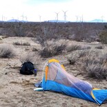
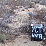
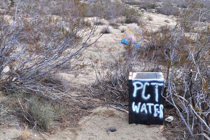
I follow my progress on my maps. Flat, straight along the aqueduct. A hard left north and the trail left the pipeline. I was 16 miles into it then. At the time, it was dark, I was beat, so here I camped. Headlamp worked well, my tent unprofessionally set up, but it blocked much of the wind. There is a water drop box close by. Along the PCT Trail, Angels assist travelers, including supplying water drops. This one was dry, too early in the season I guess. I had a full 12-oz. water bottle that I gladly consumed. "Next trip," I shouted loudly, "More Water!" I had less than 1/4 liter left by then.
It was a long night, my sleeping pad had leaks, winds creep around (and into) my tent, but I survived.
Sam White
PCT Water: This oasis is a welcome sight along the trail. Trail Angels, during the hiking season, keep this well supplied with water. Unfortunately, I'm traveling off season, and there is no water.
Finally I was stirred out of the tent, so I loaded up and headed along the trail. About a mile later, I realized I was in pain. This was when the cellphone comes in handy. I called Claudia, my personal Angel and we arranged for her pick me up on 170th Street, about two miles through the desert I needed to traverse; thankfully it was mostly downhill.
As I sat at the paved road awaiting Claudia a sign dominated. It was a standard, red "Stop" sign, and it stood out against the desert background. I looked up at the sign and think "no way". I still had another 24-miles of this part of Section E that needed to be hiked.
The sign should have read: "Pause."
Another PCT Adventure on the Trail will come soon, read about it here in The Loop and find this article online at http://theloopnewspaper.com for color photos.